
YMCA Trail
Overview
0.2 miles
0 Roads,
0 Driveways
![]()
![]()
A short access trail from the Coal Creek YMCA to the Coal Creek Trail
Description
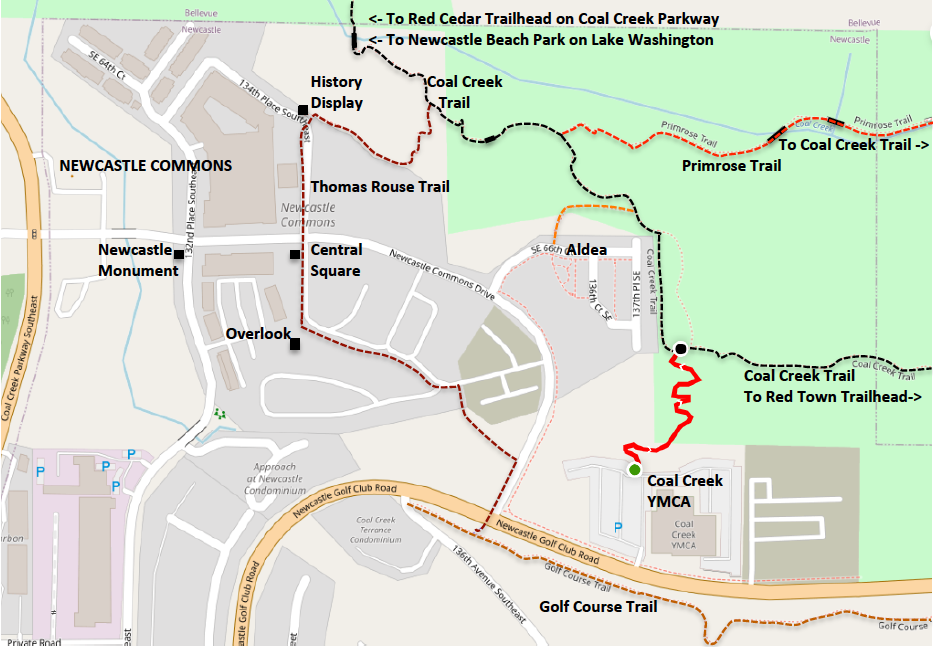
The YMCA Trail provides access to Bellevue's Coal Creek Trail from the parking lot of the Coal Creek YMCA on Newcastle Golf Club Road. Although it's entirely within Newcastle, the YMCA Trail is owned and maintained by Bellevue, and marked at both ends with Bellevue trail signs. See Extended Description below.
| Hide Trail Map | ||
|
||
1. The YMCA Trail starts on the north side of the YMCA parking lot, north and a bit west from the front entrance. The trail is marked by a Bellevue trail sign.
2. The trail descends into a pleasant wooded valley and ascends on switchbacks to join the Coal Creek Trail. From here you can follow the trail southeast to the Red Town Trailhead for Cougar Mountain Park, or northwest to Coal Creek Parkway and on to the trailhead near I-405, where a walking route continues to the Eastrail and Newcastle Beach Park on Lake Washington (see Newcastle-Cougar Map).
Loop Walks
A History Loop has been used for a series of family trail walks sponsored by the Coal Creek YMCA. Take the YMCA trail to the Coal Creek Trail and follow it southeast on an old railroad route past waterfalls to the remains of a historic mining town; return on the Golf Course Trail (see History for details).
The Primrose Loop includes two trails: the scenic Primrose Trail, and the section of the Coal Creek Trail that connects its end-points. The three nearest access points are shown on the map above.
For an easy Primrose Loop from the Commons, follow the Thomas Rouse Trail down to the Coal Creek Trail. Turn left onto the Primrose Trail, and follow it along the creek. Return on the Coal Creek Trail, but take the Aldea Trail back to the Commons. You'll avoid a steep descent and a steeper ascent, saving time and energy.
Access Trails
The YMCA Trail is an access trail, defined as a short trail that provides access to a larger primary trail – an official trail designated by a public agency and maintained under its authority. There are dozens of access trails within Newcastle, most nameless and informal footpaths, without trail signs, created and maintained by local use. Newcastle Trails shows some (but not all) access trails on the NT Trail Map, generally as short thin light-green lines. But the map above includes three special cases, all marked with trail signs:
1. The YMCA Trail, a Bellevue access trail.
2. The Aldea Trail, a Newcastle access trail.
3. The Thomas Rouse Trail, a primary trail used as an access trail.
Since most access trails have no official name, it's convenient to name them informally after their starting point (trailhead), which could be a building (YMCA), a development (Aldea, Newcastle Vista), a park, or a named trailhead.
Trailheads and Access Points
A trailhead is the starting point of a trail. An access point is any place where a walker can join the trail. Every trail has one access point (the trailhead). The Coal Creek Trail has many access points: the trailhead near I-405; formal and informal access trails from adjoining neighborhoods; the Red Cedar Trailhead on Coal Creek Parkway; the Commons; Aldea; the YMCA; the Cinder Mine Trailhead on Newcastle Golf Club Road, and the Red Town Trailhead in Cougar Mountain Park.
The Cinder Mine Trailhead is a trailhead – for an access trail (the Cinder Mine Trail) that descends to the Coal Creek Trail. The Red Cedar Trailhead adjoins the Coal Creek Trail where it passes under Coal Creek Parkway. This makes it the trailhead for an access trail (the Red Cedar Trail) of length zero – a null trail, of interest only to mathematicians. In any case, both access points provide an important trailhead amenity: public parking.