
Sylvan Trail
Overview
1.1 miles 0 Roads, 0 Driveways
From the CrossTown Trail in Hazelwood Ridge to the Horse Trail near May Creek Park.
Description
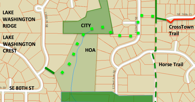
In Newcastle's Comprehensive Plan, the proposed Sylvan Trail starts at the junction of the Horse Trail and CrossTown Trail in Hazelwood Ridge, runs southwest to Newport Hills Creek and Lake Washington Crest, and follows the creek south to rejoin the Horse Trail just north of May Creek Park. An approximate route is shown in the Trail Plan, which also shows the 80th Street Trail extended east to join the Sylvan Trail in Lake Washington Crest. This illustrates an important fact: Completing the Sylvan Trail will also provide a much-needed trail connection from West Newcastle via 80th Street to the rest of Newcastle's trail system. The Sylvan Trail has four segments:
1. CrossTown Trail to Lake Washington Crest. The first part of this segment is on public land: a public access to 122nd Place SE, a sidewalk, a utility corridor from 122nd to an open space parcel owned by the City. But an easement is needed to complete the trail south to the Lake Washington Crest access trail (see Future Plans below).
2. Lake Washington Crest to 84th Street Trail. Years ago, an informal trail followed the creek to the 84th Street Trail. It's closed now, but new possibilities may arise. One possible future route runs east of Newport Hills Creek, rising high on the hill in a beautiful Douglas fir forest, and continuing south on the 122nd Avenue SE public corridor. For now, the trail could be routed south from 80th Street using existing sidewalks on 119th Ave SE and 121st Ave SE.
3. 84th Street Trail to May Creek Park Assemblage. This segment exists as an unmarked trail along the east boundary of the Cottington neighborhood. It passes between a retention pond and wetlands, and continues south to SE 84th Place on a utility road. The May Creek Park Assemblage is a development under construction just south of Cottington. It extends east to the Horse Trail.
4. Assemblage to Horse Trail. This segment will be completed as part of the Assemblage, on a public trail easement granted to Newcastle. The trail will jog west a short distance on SE 84th Place, then south, passing around the west and south sides of the Assemblage to join the Horse Trail just before it crosses May Creek Park Drive and enters the Park (on 124th Avenue SE).
Future Plans
The map below shows two large open space parcels critical to the Sylvan Trail. The north parcel is owned by the City of Newcastle, the south parcel by a Home Owners Association. With an easement from the HOA, the Sylvan Trail can be routed as shown, west from the CrossTown Trail on a public access, south on 122nd Place SE, and west on a grassy utility corridor to the City parcel. Here it descends into the forested valley of Newport Hills Creek and turns south.
The map shows the first possibility for segment 1, an easy-to-build trail to an existing public access trail descending from 120th Place SE. This short segment offers three possible benefits: (a) completing the Sylvan Trail on a temporary sidewalk route; (b) connecting the 80th Street and CrossTown trails; and (c) providing a forested nature park linked to 4 major trails.
The parcel south of the HOA parcel is important. It's needed to extend the trail and expand the forest area accessible to the public. Perhaps the City could buy it, sell a buildable lot, and retain the rest as parkland. In any case, we rely on Newcastle's planners to guide development here so as to maximize contiguous forest area and trail possibilities.
a. Sylvan Trail. The sidewalk route from 80th Street to the 84th Street Trail lies entirely within Dorchester Ridge, and it ends at a cul-de-sac. Here an unmarked trail climbs steeply to the 84th Street Trail. Making it a temporary trail route, if only for a few years, might benefit local residents in two ways: the steep connection to the 84th Street Trail could be improved (and marked with a sign); and the new trail signs would advertise two new walking routes: south to May Creek Park via the MCP Assemblage; and west on the 84th Street Trail to the park planned for the new Hiemstra development.
b. 80th Street Trail. By 2024, Renton's section of the May Creek Trail will be extended under I-405 to Jones Avenue, and part of Renton's 80th Street Trail will likely be improved as part of the adjoining Canopy development. It could easily be extended to the May Creek Trail on existing sidewalks, as indicated in the Trail Plan. And Newcastle could extend its 80th Street Trail east to the CrossTown Trail on the Sylvan Trail route (no construction required). The new 80th Street Trail would still be an urban trail, mostly sidewalks, but it would connect much of West Newcastle with the May Creek and CrossTown trails. And it would include other trail connections and parkland along the way.
c. Sylvan Nature Park. The forested valley of Newport Hills Creek is a bit of rain forest surrounded by residential neighborhoods. From the valley floor you see only moss-covered trees, and fern-covered cliffs. A green oasis that should be preserved, and extended, and made accessible by trails.